Fishery spatial plans in the Ionian Sea

Lessons learnt developed in https://doi.org/10.1016/j.ocecoaman.2020.105456 along with an HCMR-DTU-Aqua cooperation for a simulation study:

We study the cost-benefits of fisheries management options in Ionian Sea.

We use a dynamic spatial bio-economic model taking into account the fishing effort displacement effect.

An effort control benefits the stocks and the economy, but unwanted catch is higher along with the recovery of stocks.

Space-time closures and selectivity improvements slightly reduce the unwanted catch and can help mitigating the problem of unwanted catch.

Placing new aquaculture sites has not affected the profit of small-scale fishery.

Fisheries impact on the seafloor: a showcase in the Baltic Sea

Lessons learnt:
• Restricting fishing areas does not equate to reducing ecosystem impacts on benthic habitats.
• Displacing fishing efforts can offset the gains in partial habitat protection.
• The benthic status in Kattegat improves more than the benthic status in central Baltic when using spatial management measures.
• Largest improvement is achieved by protecting long-lived communities from high-impact fisheries.
• Healthy fish stocks reduce the risk to both the seafloor integrity and fishery economics.

see to see what happens when contracting for example 50% of the fishing effort extent on the core fishing areas, on a pdf presentation here from the HELCOM Action project. Full publication at https://doi.org/10.1016/j.fishres.2020.105681

Growing network of fisheries modelling using DISPLACE

By analyzing fishers´ decision making consequences and predicting likely responses of fisheries to spatial management options, the DISPLACE modelling approach is assessing whether actual fishing opportunities and technical management measures (e.g. regulation of gears, spatial restriction for fishing, etc.) perform well by ensuring sustainable fishing and food provision to the value chain without affecting important fisheries economics. In this context DISPLACE now provides scenario-based assessment and projections of the amount of income generated by national fishing fleets (or other finer fleet segments level economics and fishing harbor communities) over months, quarters and years as long as national input data are available.

On this issue, important results have been obtained in a row of applications including the Adriatic Sea CS (paper here),  the Ionian Sea (in progress), the Black Sea (in progress) and the Baltic Sea CSs, with ongoing data conditioning for the Irish Celtic Sea, some Norwegian Fjords and NE Atlantic Coasts in Portugal.


National fishing fleet economic performance and sustainable use of the ocean

DISPLACE_0.9.9_DanishFleetExample

DISPLACE_0.9.9_DanishFleetExample_FleetEconomicsStatistics

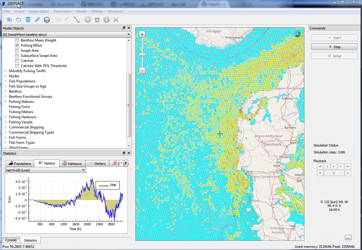
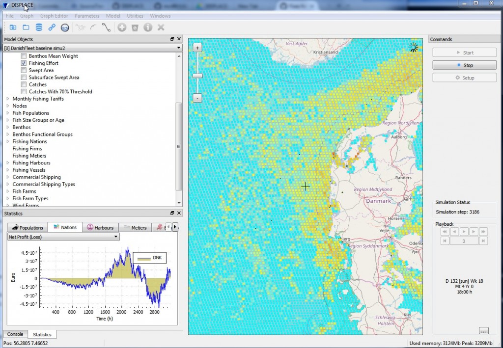
DISPLACE is a fisheries spatial ecosystem impact assessment tool that can be used to look at the consequences of fisheries and the benefits from managing them (including spatial fisheries closures) for a sustainable use and a viable economy of fisheries exploiting marine resources (fish, shellfish and marine invertebrates). The model simulates the fishing of individual vessels and their capacity to deploy their effort at fishing when constrained by spatial or temporal closures, other management, and including spatial restriction from other concurrent uses of the sea (fish farms, commercial shipping lanes, wind farm parks).

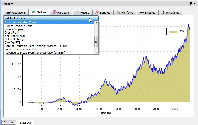
In this context, DISPLACE provides a basis for testing scenarios and projects the amount of income generated by national fishing fleets (or the economics of some finer segmentation such as fishing harbor communities) over months, quarters and years. We track aggregated economics and measure Income, Costs, Economic Indicators, Capital value, Profitability and development trends. DISPLACE is also a platform useful to compare fleet segments regarding their respective fuel efficiency and relative impacts by for example looking at the income issued from the sea for each unit of seabed area swept by the fishing gears.

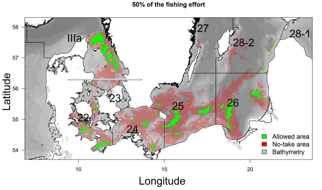
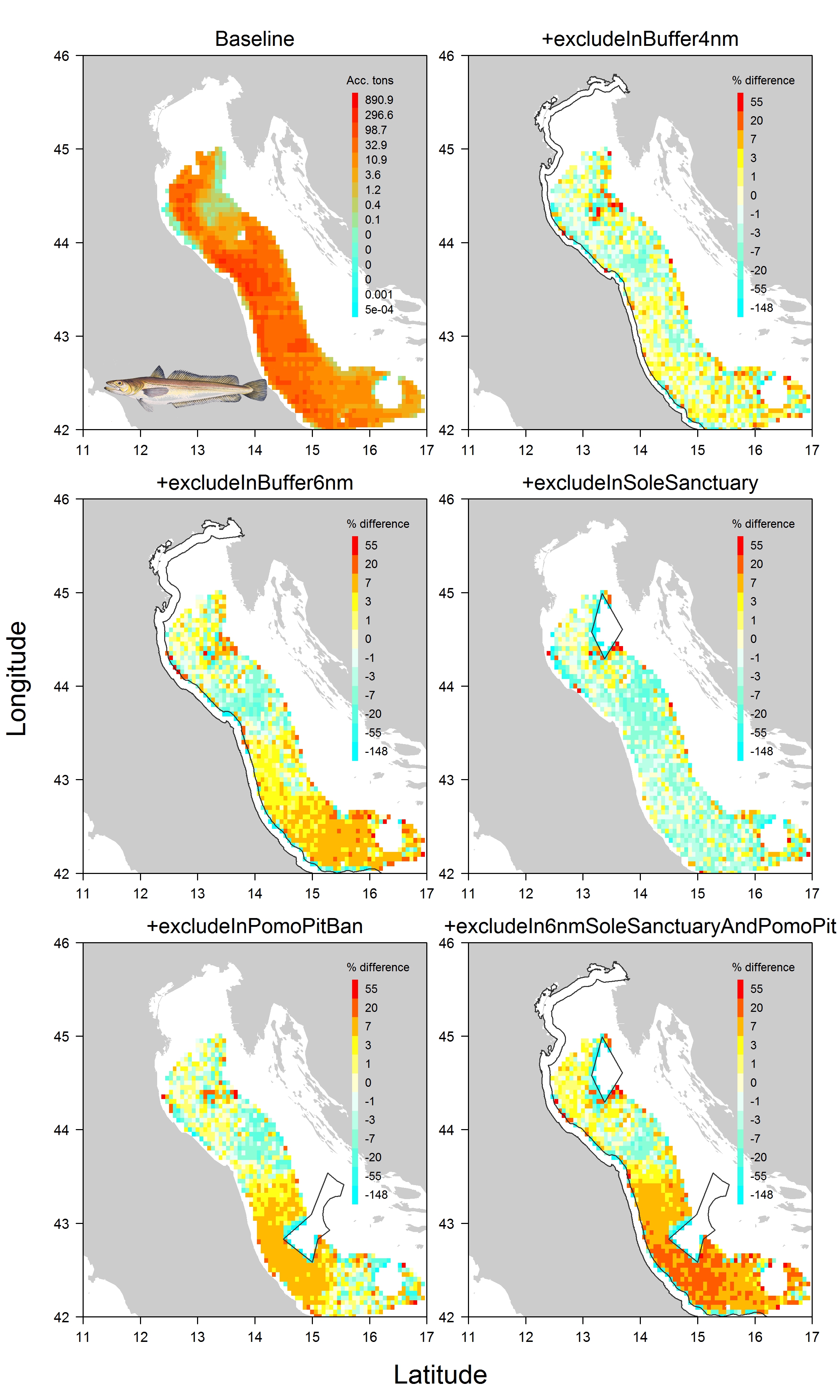
(Disclaimer! Attached screenshots in this margin are very preliminary outcomes and should not be used to give any kind of advice neither to deduce any kind of productivity levels)

Fisheries management in one of the most crowded marine area. Does spatial planning help?

The Adriatic Sea is one of the most crowded marine areas. Several fishing activities operate simultaneously in the area, and the need to minimize conflicts among them is also a social concern. We apply a fish and fisheries model accounting for space and time effects to study the impact that would result from a suite of spatial plans suggested by practitioners in order to reduce the pressure on the four main demersal fish and crustacean stocks (having high commercial interest) in the northern Adriatic. We also look at promoting space sharing between mutually exclusive activities.

Check out the open access paper for more information in Ecosphere

Figure6_revised

DISPLACE is a spatial impact assessment tool to anticipate the consequences of displacing fisheries on ensuring a better sustainability and economy of fisheries. The model simulates the activity of individual vessels and how they will use their time fishing and where given restrictions in space and time. By applying the model that fit the local fisheries of the Adriatic region, practitioners could further develop tailored applications to their area for both understanding the fine dynamic of the interlinked fish and fisheries here, and, in the meantime, acquire a helicopter view of the outcomes when the small-scale (fishing) operations at sea are aggregated. That kind of framework applied to the Adriatic or other areas should analyze and provide data with thematic reports/scenario on which the practitioners can rely on to project the fish stock population levels and fishery economy relevant to the ecoregion. The model contributes to the coordination and integration of different spatial activities in marine areas with the purpose of reducing potential inefficient management and use of space in accordance with the aims of the EU Marine Spatial Planning Directive (MSPD) and other Directives. In the project, the model is used to estimate the consequences of closing specific areas to fishing.

Impact assessment of spatial planning on the fishery economy and ecosystems

In the competition for marine space, the fishing sector needs to prepare for management impacts from other directives than the EU Common Fishery Policy. Our purpose is to support the sector-specific stakeholders and policymakers and provide them with a tool for evaluating the spatial planning and management scenarios and spatial explicit fishery dynamics. This tool is informed by the different types of fishing activities and other activities occupying marine space. Continue reading “Impact assessment of spatial planning on the fishery economy and ecosystems”

Have your say on how spatial restrictions affect your fishing

COLOURBOX4013895_smallIn relation to present simulations performed under the Baltic case study of the SOCIOEC project, the stakeholder feedback is expected to provide information on (and contribute to) what the stakeholders consider to be the most important risk factors in such spatial management. Furthermore, they are expected to contribute with information on how they plan to react to the spatial management measures in their short-term decision making (on a daily basis or at the trip level). For example, how they will react to increased fuel prices? Or how increase price is changing the choices of fishing grounds? Or how do fishermen react to some stocks with altered productivity? Or do they switch to another ground, fisheries, occupation, etc.? Or do they on a longer-term basis change their investment dynamics, exit from fishery, etc.?.) . Continue reading “Have your say on how spatial restrictions affect your fishing”

How spatial planning constrains cross-border fisheries: the bio-economic DISPLACE evaluation on the Baltic Sea

DISPLACE_striking_plotWith our approach we aim at modelling the interaction between fisheries and stock spatial dynamics and assessing the interlinked consequences on both the vessel economy and the viability and sustainability of the harvesting (including the issue of energy efficiency for greener fisheries). We explore  alternative fishing effort allocation scenarios and management options. As such, we are designing a benchmark tool for conducting management strategy evaluations to capture short-term economic reactions from individual fisherman tactical decision-making.

In the growing marine spatial planning (MSP) legislative context, concurrent uses of the sea are constraining the possibilities of displacing each vessel´s fishing activities. These new constraints call for studies that would empower the fishing industry with the right tools and knowledge to engage in fair MSP dialogues. We should consider the impact assessment and scenario evaluation of wider marine cross-sector use, exploitation of the marine environment and competition for space in a spatial evaluation tool and our ongoing evaluation is precisely dedicated to investigating this aspect.

Continue reading “How spatial planning constrains cross-border fisheries: the bio-economic DISPLACE evaluation on the Baltic Sea”