Engage the virtuous spiral in fisheries

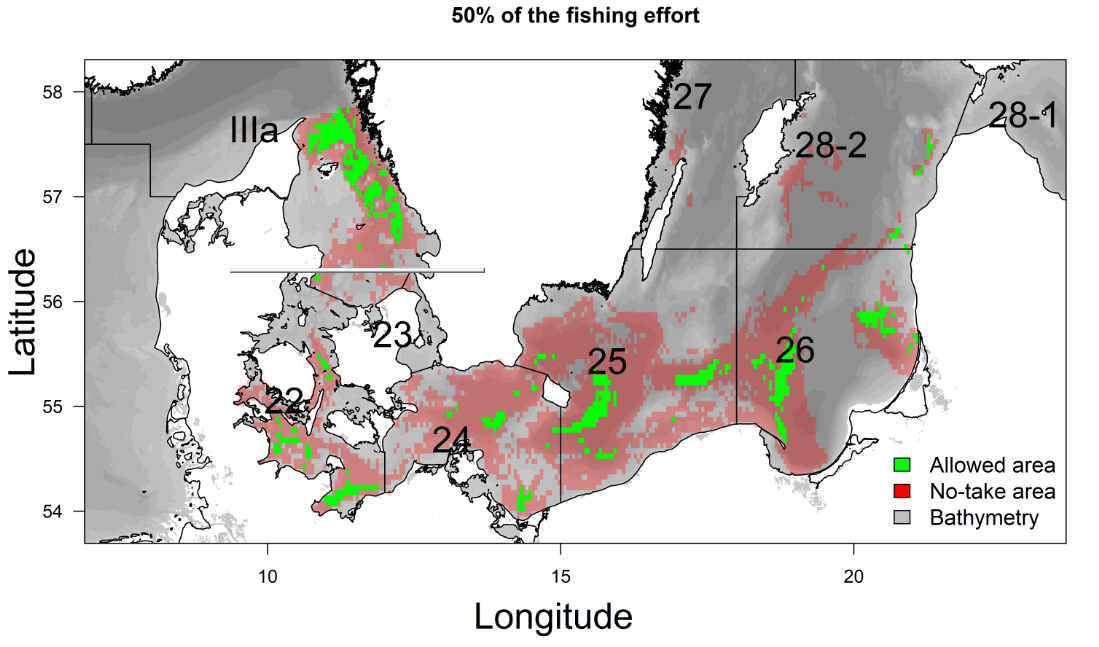
Acting with imperfect information, fisheries policymakers and managers must try to balance tradeoffs of fisheries short-term productivity against long-term environmental, economic and social sustainability.

Alternatively, both environmental and fisheries policy strategies could engage a virtuous circle by bridging the historical divide between fisheries and nature agencies.

Hence, a long-term win-win situation could better emerge, and by propagating the change induced by the reduction of fishing impacts to other supportive marine ecosystem components (habitats, non-commercial marine species), the fisheries management could contribute to secure future fishing opportunities for the fishing fleets along with fulfilling the market demand for seafood and ensuring coherence in meeting national environmental targets.

Building on previous scientific works, we contributed to making this point more apparent in:

Bastardie, F., & Brown, E. J. (2021). Reverse the declining course: A risk assessment for marine and fisheries policy strategies in Europe from current knowledge synthesis. Marine Policy, 126, [104409]. https://doi.org/10.1016/j.marpol.2021.104409

You are welcome to ask for a free copy of the published article to fba at aqua.dtu.dk or find a preprint version here:

Fishery spatial plans in the Ionian Sea

Lessons learnt developed in https://doi.org/10.1016/j.ocecoaman.2020.105456 along with an HCMR-DTU-Aqua cooperation for a simulation study:

We study the cost-benefits of fisheries management options in Ionian Sea.

We use a dynamic spatial bio-economic model taking into account the fishing effort displacement effect.

An effort control benefits the stocks and the economy, but unwanted catch is higher along with the recovery of stocks.

Space-time closures and selectivity improvements slightly reduce the unwanted catch and can help mitigating the problem of unwanted catch.

Placing new aquaculture sites has not affected the profit of small-scale fishery.

Fisheries impact on the seafloor: a showcase in the Baltic Sea

Lessons learnt:
• Restricting fishing areas does not equate to reducing ecosystem impacts on benthic habitats.
• Displacing fishing efforts can offset the gains in partial habitat protection.
• The benthic status in Kattegat improves more than the benthic status in central Baltic when using spatial management measures.
• Largest improvement is achieved by protecting long-lived communities from high-impact fisheries.
• Healthy fish stocks reduce the risk to both the seafloor integrity and fishery economics.

see to see what happens when contracting for example 50% of the fishing effort extent on the core fishing areas, on a pdf presentation here from the HELCOM Action project. Full publication at https://doi.org/10.1016/j.fishres.2020.105681

Supporting evidence-based marine policy making with impact evaluations

Sophisticated computer simulations can support effective science-based evaluations to facilitate better governance of the marine space with evidence-based policies. We developed a range of spatial fisheries models, integrating biological with fishers´decision-making dynamics and management for assessing the management of multiple activities. We present the outcomes of case-specific evaluations with different ecological and socio-economic characteristics i.e. Adriatic, Ionian, Black, Baltic and Celtic Seas, and priorities like fisheries, aquaculture, offshore wind energy or conservation areas. For each case, we applied the DISPLACE agent-based modeling platform for simulating bioeconomic dynamics and clarifying options for sustainable and viable fisheries in presence of other marine sectors. The work is ongoing and we foresee clear outcomes delivered by mid-2019.

Testing to what extent EU fisheries can cope with a ban of discarding fish in presence of choke species

The ban on discarding unwanted fish overboard when fishing, which was decided during the last 2013 EU Common Fisheries Policy reform, requires that everything retained in a commercial fishing gear is recorded and counted against fish quotas when some exist like in Northern European waters. It is, however, difficult to reduce catches of a single fish species when a variety of fish is generally caught together. This creates a risk for early closures of fisheries when the quota of one fish (the “choke species”) is exhausted before the others. To cope with this and avoid an unnecessary low rate of quota utilization, fishermen can try to lease extra quotas, or modify their catches, either by switching to more selective fishing gear types or through changes in when, where and how to fish, by trying to avoid areas where there is a fair amount of possible choke species, and displace the fishery as soon as a large catch of choke species is encountered. This ability to displace will depend on the skills and choices of the skipper but also on how the fish stocks distribute in space and time (patchily vs. evenly distributed). We are developing here a platform to test such interlinked effects in a clear and detailed manner by accounting for varying skipper’s decision-making, such as for example the one described in the adjacent decision tree.

Growing network of fisheries modelling using DISPLACE

By analyzing fishers´ decision making consequences and predicting likely responses of fisheries to spatial management options, the DISPLACE modelling approach is assessing whether actual fishing opportunities and technical management measures (e.g. regulation of gears, spatial restriction for fishing, etc.) perform well by ensuring sustainable fishing and food provision to the value chain without affecting important fisheries economics. In this context DISPLACE now provides scenario-based assessment and projections of the amount of income generated by national fishing fleets (or other finer fleet segments level economics and fishing harbor communities) over months, quarters and years as long as national input data are available.

On this issue, important results have been obtained in a row of applications including the Adriatic Sea CS (paper here),  the Ionian Sea (in progress), the Black Sea (in progress) and the Baltic Sea CSs, with ongoing data conditioning for the Irish Celtic Sea, some Norwegian Fjords and NE Atlantic Coasts in Portugal.


How spatial planning constrains cross-border fisheries: the bio-economic DISPLACE evaluation on the Baltic Sea

DISPLACE_striking_plotWith our approach we aim at modelling the interaction between fisheries and stock spatial dynamics and assessing the interlinked consequences on both the vessel economy and the viability and sustainability of the harvesting (including the issue of energy efficiency for greener fisheries). We explore  alternative fishing effort allocation scenarios and management options. As such, we are designing a benchmark tool for conducting management strategy evaluations to capture short-term economic reactions from individual fisherman tactical decision-making.

In the growing marine spatial planning (MSP) legislative context, concurrent uses of the sea are constraining the possibilities of displacing each vessel´s fishing activities. These new constraints call for studies that would empower the fishing industry with the right tools and knowledge to engage in fair MSP dialogues. We should consider the impact assessment and scenario evaluation of wider marine cross-sector use, exploitation of the marine environment and competition for space in a spatial evaluation tool and our ongoing evaluation is precisely dedicated to investigating this aspect.

Continue reading “How spatial planning constrains cross-border fisheries: the bio-economic DISPLACE evaluation on the Baltic Sea”