Fishery spatial plans in the Ionian Sea

Lessons learnt developed in https://doi.org/10.1016/j.ocecoaman.2020.105456 along with an HCMR-DTU-Aqua cooperation for a simulation study:

We study the cost-benefits of fisheries management options in Ionian Sea.

We use a dynamic spatial bio-economic model taking into account the fishing effort displacement effect.

An effort control benefits the stocks and the economy, but unwanted catch is higher along with the recovery of stocks.

Space-time closures and selectivity improvements slightly reduce the unwanted catch and can help mitigating the problem of unwanted catch.

Placing new aquaculture sites has not affected the profit of small-scale fishery.
Supporting evidence-based marine policy making with impact evaluations

Sophisticated computer simulations can support effective science-based evaluations to facilitate better governance of the marine space with evidence-based policies. We developed a range of spatial fisheries models, integrating biological with fishers´decision-making dynamics and management for assessing the management of multiple activities. We present the outcomes of case-specific evaluations with different ecological and socio-economic characteristics i.e. Adriatic, Ionian, Black, Baltic and Celtic Seas, and priorities like fisheries, aquaculture, offshore wind energy or conservation areas. For each case, we applied the DISPLACE agent-based modeling platform for simulating bioeconomic dynamics and clarifying options for sustainable and viable fisheries in presence of other marine sectors. The work is ongoing and we foresee clear outcomes delivered by mid-2019.

Growing network of fisheries modelling using DISPLACE

By analyzing fishers´ decision making consequences and predicting likely responses of fisheries to spatial management options, the DISPLACE modelling approach is assessing whether actual fishing opportunities and technical management measures (e.g. regulation of gears, spatial restriction for fishing, etc.) perform well by ensuring sustainable fishing and food provision to the value chain without affecting important fisheries economics. In this context DISPLACE now provides scenario-based assessment and projections of the amount of income generated by national fishing fleets (or other finer fleet segments level economics and fishing harbor communities) over months, quarters and years as long as national input data are available.

On this issue, important results have been obtained in a row of applications including the Adriatic Sea CS (paper here),  the Ionian Sea (in progress), the Black Sea (in progress) and the Baltic Sea CSs, with ongoing data conditioning for the Irish Celtic Sea, some Norwegian Fjords and NE Atlantic Coasts in Portugal.


Fisheries management in one of the most crowded marine area. Does spatial planning help?

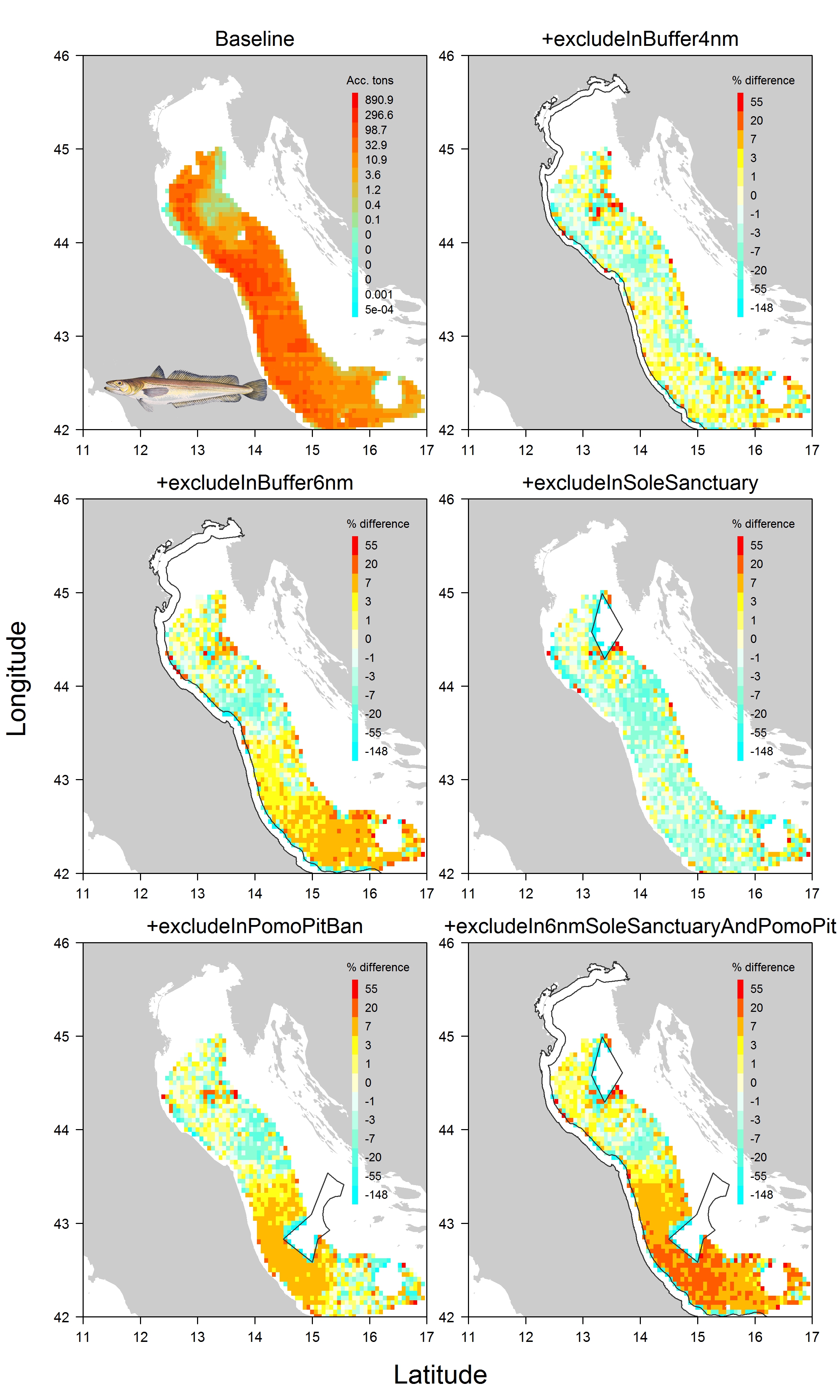
The Adriatic Sea is one of the most crowded marine areas. Several fishing activities operate simultaneously in the area, and the need to minimize conflicts among them is also a social concern. We apply a fish and fisheries model accounting for space and time effects to study the impact that would result from a suite of spatial plans suggested by practitioners in order to reduce the pressure on the four main demersal fish and crustacean stocks (having high commercial interest) in the northern Adriatic. We also look at promoting space sharing between mutually exclusive activities.

Check out the open access paper for more information in Ecosphere

Figure6_revised

DISPLACE is a spatial impact assessment tool to anticipate the consequences of displacing fisheries on ensuring a better sustainability and economy of fisheries. The model simulates the activity of individual vessels and how they will use their time fishing and where given restrictions in space and time. By applying the model that fit the local fisheries of the Adriatic region, practitioners could further develop tailored applications to their area for both understanding the fine dynamic of the interlinked fish and fisheries here, and, in the meantime, acquire a helicopter view of the outcomes when the small-scale (fishing) operations at sea are aggregated. That kind of framework applied to the Adriatic or other areas should analyze and provide data with thematic reports/scenario on which the practitioners can rely on to project the fish stock population levels and fishery economy relevant to the ecoregion. The model contributes to the coordination and integration of different spatial activities in marine areas with the purpose of reducing potential inefficient management and use of space in accordance with the aims of the EU Marine Spatial Planning Directive (MSPD) and other Directives. In the project, the model is used to estimate the consequences of closing specific areas to fishing.